Think of a land with an intricate network of salt marshes, beaches, wetlands, springs and streams, surrounded by water and prone to naturally occurring floods.
Add a population of over 1.6 million and transform it in one of the most densely populated areas in the world. Now make it the commercial, economic, and cultural center of the United States, and one of the financial centers of the world.
The result is Manhattan, a Metropolis of unspeakable fragility, whose very survival is entirely dependent on a multitude of infrastructural systems of extraordinary scale and complexity: mass transit systems, power and fuel supply lines, accessibility and transportation infrastructure. All of which tragically failed last week.
Hurricane Sandy unveiled a disturbing reality: every piece of critical infrastructure in the city is placed under sea level and left unguarded against a predictable storm surge.
We will have to rethink our infrastructural systems from scratch and we only have a few years to do it, before Nature restores Manhattan’s original coastline – and sends 400 years of civil engineering down the drain.

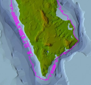
This digital elevation model shows the original topography of Manhattan in 1609. The pink line shows the current outline of the Island.
(photo credit: Markley Boyer, The Mannahatta Project, Wildlife Conservation Society)

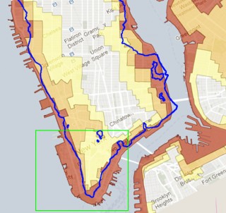
On the Hurricane’s Evacuation Map provided by the City of New York, Zone A (in red) is the area with the highest flood risk. Interestingly, Zone A retraces the original waterfront of the Island, circa 1609 (blue outline).

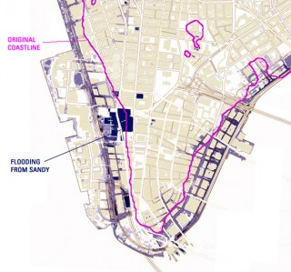
The eastern line of the Island’s original coastline runs along Greenwich Street, while the western line lies near Pearl Street. Areas of Manhattan that were flooded from Hurricane Sandy (blue on the map) are almost exactly the areas that were built up by landfill.